

“The lakes we measured were gray areas on our otherwise detailed maps,” says Maartje Korver, the Hakai Institute scientist contorted in the center of the canoe.
While a plane or a drone can measure a lake’s area, measuring depth is more complicated. Untangling it requires a mapping technique called bathymetry, the underwater equivalent of a topographic map on land. But instead of lines that illustrate an elevation, bathymetric maps have lines that show water depth.
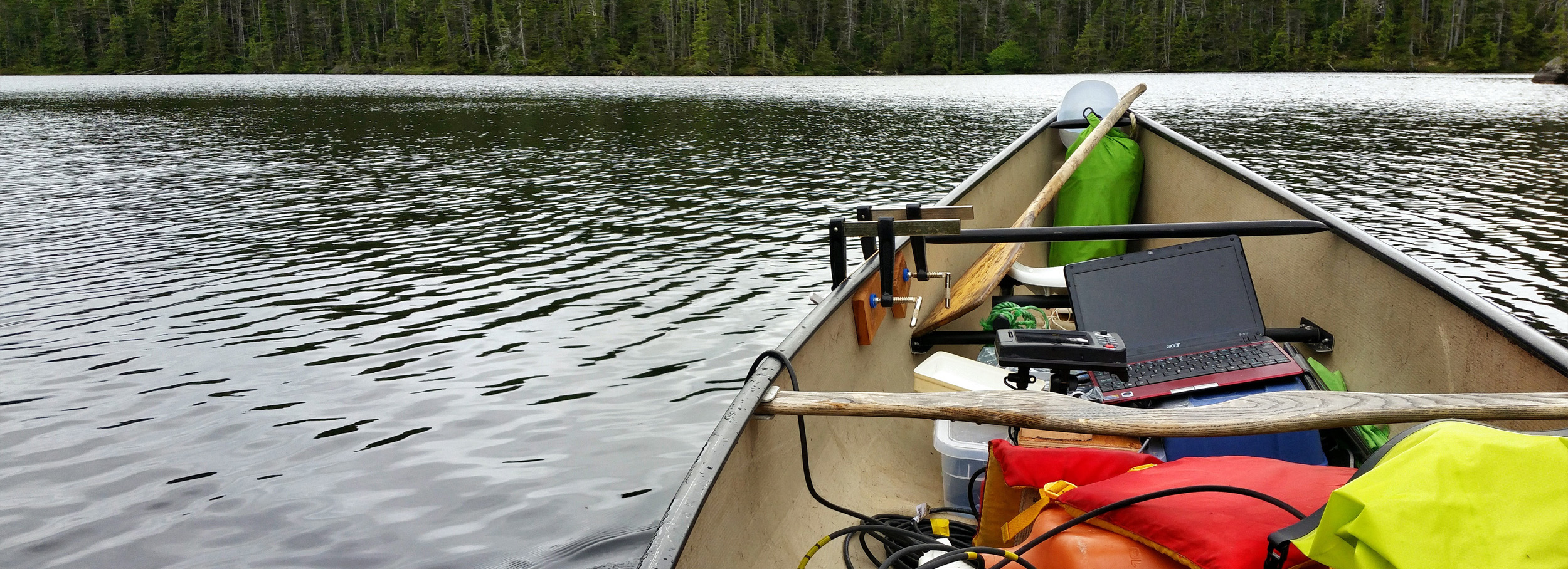
A common way to measure depth is using a sounder. Mounted at the side of a ship, depth sounders transmit sound waves into the water and record the time it takes to reflect off the bottom and return to the boat.
One problem: standard depth sounders aren’t designed for canoes. These lakes are only accessible by bushwhacking for kilometers over uneven terrain, and bringing in a larger boat would have been a logistical nightmare.
“We had to have something really lightweight and compact that we can either hike in or can fit with us in a helicopter,” says Korver.
But the Hakai Institute’s Wayne Jacob, never one to back down from an engineering challenge, designed just such a system—a depth sounder the size of a car battery that could clamp onto a canoe while connected to a laptop. The system worked, but even with a bespoke depth sounding system, the fieldwork was arduous. Reading the measurements required one team member to stay hunched over the laptop in the center of the canoe for hours upon hours. Korver drew the short straw.
“The setup is not designed for comfort,” says Korver. “I had no blood flow left after sitting for that long in a canoe.”
Giesbrecht had a slightly better vantage point from the relatively luxurious position of paddler.
“Paddling a lake so systematically was kind of meditative, and a fun challenge,” says Giesbrecht. “It’s somewhat like mowing a lawn or shoveling a driveway, where you want to stay parallel to your last pass.”
From Canoe to Computer

Back in the dry confines of their offices, Santiago Gonzalez Arriola and the rest of the Hakai mapping team spent hours translating the sounding data into a useable model of the lake. According to Gonzalez Arriola, a mapping aficionado, the resulting three-dimensional lake maps make it almost seem like you are there on the lake in a canoe. He describes the maps as, “only inferior in beauty to those experienced by the paddlers in the field.”
With their new three-dimensional model of the lake, the scientists turned to answer an important question in this part of the world—how does the lake’s depth change when a big storm wallops the coast? To answer that, they created a lake “volume calculator.” Essentially, the computer-modeled lake can be digitally filled or emptied, and the volume of the lake can be calculated at any depth. This lets the scientists model what the lake looks like and how much water it holds with different amounts of rainfall or storm runoff. And that helps them learn how many nutrients the animals downstream can expect to get after the next storm and better model the whole connected coastal ecosystem.
“I’m in a happy place out there, canoeing and exploring a remote lake, the whole time thinking about how we’re going to use a computer to create rich visual representations of the hidden lake bottom,” says Giesbrecht. “Lake depth mapping really completes the picture within our watersheds.”
Acknowledgements
In addition to Maartje and Ian, other intrepid paddlers that helped on the expedition included: Allison Oliver, Ben Millard-Martin, Kaia Bryce, Alex Hare, Will McInnes, and Lori Johnson.